
Search and Rescue training held at Prairie Heritage Center
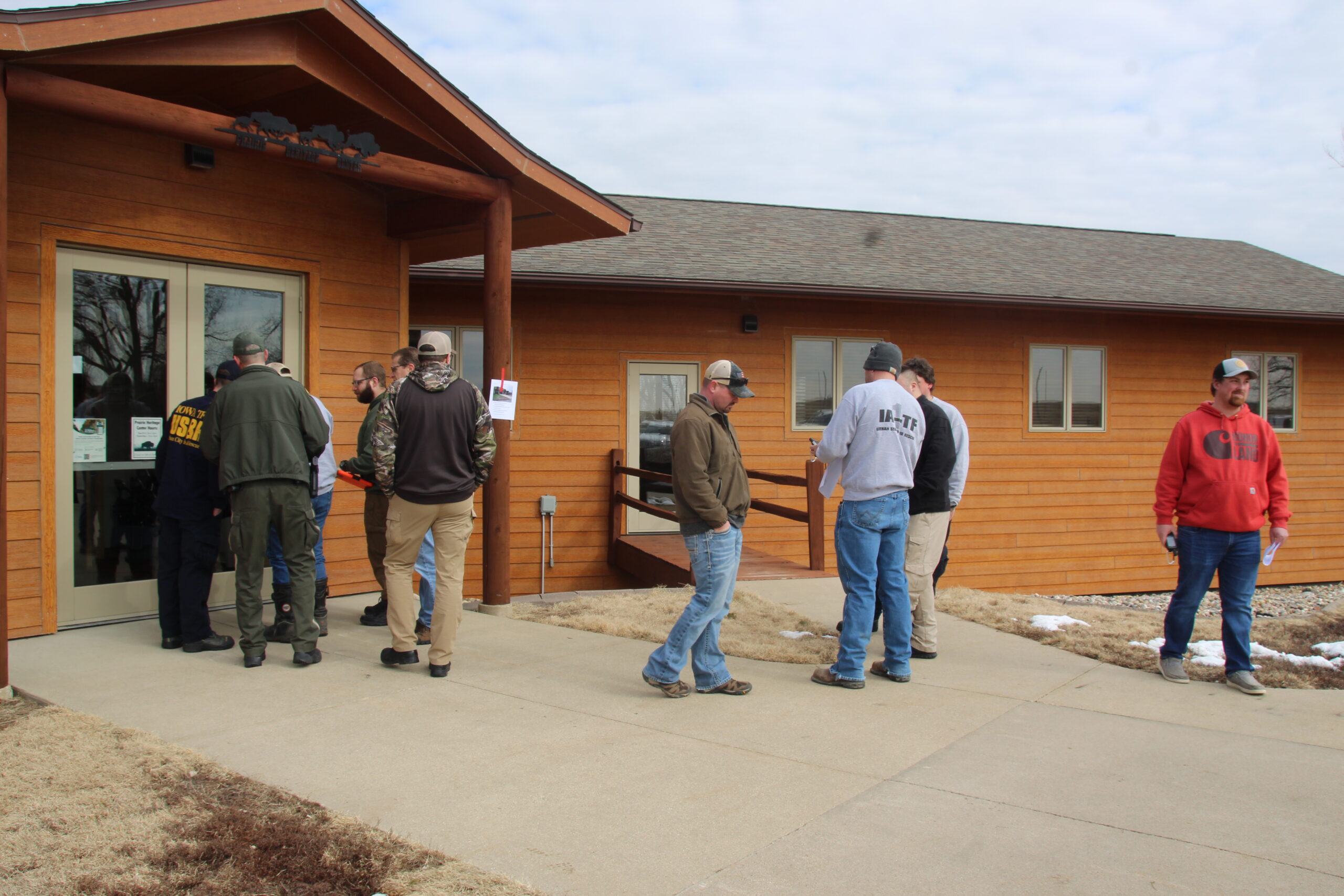
On Saturday, March 25 area Fire and Rescue and Law Enforcement departments gathered at the Prairie Heritage Center near Peterson to do some Search and Rescue training conducted by O’Brien county Emergency Management, Northwest Iowa Community College and IA Task Force 1. This training provided the group with new knowledge and skills over the United States National Grid System (USNG) that can be use in search and rescue operations . There was a total of about twenty in attendance from the Primghar Fire Department, Paullina Fire Department, O’Brien County Sheriff Department, Peterson Fire and Rescue Department, Sibley Fire and Rescue Department and the O’Brien County Conversation. The IA Task Force 1 out of Sioux City lead the class teaching their knowledge on how to read USNG goordinates on a map, how to read trail markers and use the USNG in search and rescue operations using GPS devices or phone apps. The IA Task Force 1 said that GPS devices work okay but the information is six hours old were as using a phone or tablet now is minutes old. After some class discussion the group went out into the field to use their knowledge and GPS devices provide to them by the IA Task Force 1 to do a scavenger hunt. After the scavenger hunt the group had some discussion on what they learned and different technologies that could be used in search and rescue. The information was very informative.
Jared Johnson O’Brien County Emergency Management told us “I thought that the training went very well. I appreciate the assistance from Northwest Iowa Community College and IA Task Force 1 to help get this training set up. This training provided us with new knowledge and skills over the United States National Grid System that we can use in search and rescue operations. The training location at the Prairie Heritage Center worked out great.
After a disaster, when the “normal” means to describe locations, such as street signs, are gone, the U.S. National Grid provide a standardized grid reference system that is seamless across jurisdictional boundaries and allows for pinpointing exact locations.
Since USNG is standardized, it can be understood and used as a common geographic framework for response. The USNG is a multi-purpose location system of grid references used in the United States. It provides a nationally consistent “language of location”, optimized for local applications, in a compact, user friendly format. It is similar in design to the national grid reference systems used in other countries. The USNG was adopted as a national standard by the Federal Geographic Data Committee (FGDC) of the US Government in 2001. National Grid is much easier to use than longitude and latitude. For one thing, the coordinates measure actual distances on the ground. Emergency workers in the path of Katrina used these coordinates to find their way around.
In the early, crucial stages of a disaster or emergency and throughout the disaster process, responderss, emergency managers, public works and utility entities, and the general public use geospatial technologies and products (maps) because they provide important information, quickly and in ever more so easy-to-understand standardized formats. Every day there are hundreds of natural disasters world-wide. Some are dramatic, whereas others are barely noticeable. A natural disaster is commonly defined as a natural event with catastrophic consequences for living things in the vicinity. Those events include earthquakes, floods, hurricanes, landslides, tsunami, volcanoes, and wildfires. Human-caused disasters are events that are caused by man either intentionally or by accident, and that directly or indirectly threatens public health and well-being. These occurrences span the spectrum from terrorist attacks to accidental oil spill
To assist in planning and preparing for, mitigating of, and responding to emergencies and natural and potential human-caused disasters, geospatial technologies help ensure a unified and informed enterprise, effective command and control and rapid coordination through accurate and precise exchange and communication of spatial information. Every activity related to incident response, from command and coordination, logistical support, to informing the public is related to the location of things, events, and people.
Iowa Task Force 1 (IA-TF1) is Iowa’s Urban Search and Rescue (USAR) team. IA-TF1 team members have been trained and equipped to locate, rescue and provide initial medical stabilization to victims in confined spaces, including collapsed structures, grain silos, mines and collapsed trenches. The team is also trained in swift-water rescue and wide area search.
In addition, the team may loan equipment like generators, light kits, and communications equipment for local responders. Iowa Task Force 1 was built using existing capabilities and resources, is comprised of the Sioux City and Cedar Rapids Fire Departments, and draws additional membership from fire and rescue professionals from across Iowa. They said they would respond when needed and help anyway they could but they wouldn’t take over and operation unless asked to. The purpose of the training they provide is to give departments the tools needed to do effective search and rescues. There are about 30 members in the Sioux City Crew and about 30 members in the Cedar Rapids Crew.
The mission of Iowa Task Force-1 (IA-TF1) is to provide the citizens of Iowa with a highly trained and well equipped USAR team to be used for statewide emergencies.
In 2003, the Sioux City and Cedar Rapids Fire Departments were selected to be the sponsoring agencies for Iowa’s state Urban Search & Rescue team, with each agency soliciting volunteers from their department as well as responders from other city, state and local agencies. The team, known as Iowa Task Force-1, began to take shape in November of 2003. The team became a deplorable asset for statewide emergencies in the summer of 2004.
The Iowa Task Force 1 Specialties are:
• Search
• Confined Space Rescue
• High Angle Rescue
• Swift water Rescue
• Breaching & Breaking
• Shoring
•USNG Incident Command System
• Canine Response
• Engineering
• Emergency Medical Services
• Communications
• Logistics
Past Deployments
• Parkersburg Tornado
• Floods of 2008
• Multiple Missing persons
• Maquoketa Cave Rescue
• Oelwein Fire
• Little Sioux Boy Scout Ranch Tornado
• Des Moines Younkers Fire